Moving on from ARGs Uncovered, which reviewed the IGDA white paper on Alternate Reality Games (ARGs), this post provides you with an opportunity to find out for yourself a little more about the design of the first Perplex City ARG.
First up is a presentation by Adrian Hon (who you may remember we’ve come across before…), of the game development company Mind Candy, which created the original Perplex City ARG as well as its successor….
To set the scene, you may like to read a little bit of background about the game by reading this review of Perplex City… The Wikipedia entry for Perplex City also provides a brief summary of the game.
So now you sort of know what it is, let’s here about the game from the inside: “Alternate Reality Games and Perplex City Season 2”, by Adrian Hon (Google Tech Talks)
Whilst you are listening to the presentation – or maybe afterwards? ;-) – you may like to visit the Perplex City Season 1 retrospective website.
One of the great features of this site is an archive of some of the design notes used when creating the game (Perplex City Season One Story Planning).
You may notice that the game was storyboarded using a series of flowcharts to describe the order of events that were planned for the game. Flowcharts can be used to provide a very concise summary of the key actions and decision points that must be negotiated in a game in order for the story to progress. They can also reveal the complexity of a game’s design at a glance!
The site also contains a brief history of the evolution of the Perplex City map that provided a solid foundation for the game.
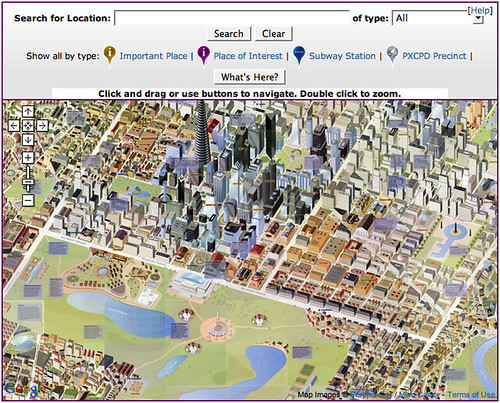
You can still explore an interactive version of the Perplex City map at http://www.perplexcitymap.com/.

I just noticed that a with the release of GTA IV (Grand Theft Auto IV), a Google map of the Liberty City, the setting of the game, has also appeared:
http://grandtheftauto.ign.com/maps/1/Liberty-City-Map
If you create a large 3D world and expect the player to be able to learn the geography of the place, bear in mind that the player will find it increasingly difficult to learn their way around as the world gets bigger.
The following article suggests several ways to help the player find their way around the game world.
“Design Lesson: The ability for landmarks to sufficiently guide the player around the game world dramatically decreases as the size of the world increases.”
http://www.gamesetwatch.com/2008/04/column_design_lesson_101_grand.php
One widely used way of helping the player around is to have dominant landmarks that the player can use to help work out where in the world they are, but these rapidly lose their effectiveness (i.e. the player is more likely to be confused as to the actual location of each landmark, and their positions relative to one another) as the world gets larger.
Another approach is to have a ‘minimap’ display that shows whereabouts in the overall game map the player is located, as well as possible goals and threats.